Rail Trails | Worcestershire
Free station to station walking guides in Worcestershire
Rail trails | The Saltway Line


Walks along the line

Worcester Foregate Street to Droitwich Spa

Droitwich Spa to Bromsgrove

Bromsgrove to Barnt Green

Worcester Foregate Street to Droitwich Spa
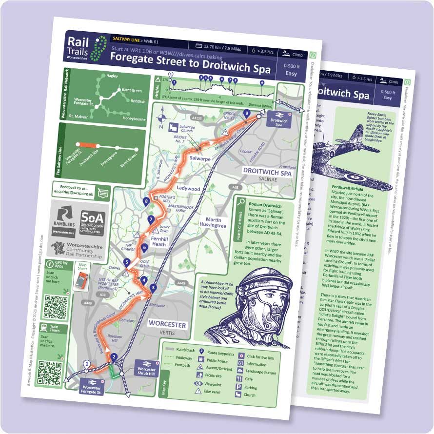

19.3 Km /12.1 Miles | Easy | > 4.5 hours
Route summary
With a more scenic diversion around Fernhill Heath, most of route follows the Worcester and Birmingham and Droitwich canal sections of the Monarch’s Way.
Important
Unfortunately the last section of the Foregate to Droitwich Walk is closed for 12 weeks.
The towpath from Vines Lane in Droitwich to Ladywood Lock in Salwarpe is closed for 12 weeks for resurfacing, with the path expected to re-open in September.
https://www.worcesternews.co.uk/news/25184152.inaccessible-droitwich-canal-towpath-fenced-off-public

Interactive PDF Sheet Route 1

.GPX Route 1 file
- Reminder – GPX route files can only be viewed if you have installed an app which can handle these files onto your phone or device.

Droitwich Spa to Bromsgrove


12.4 Km / 7.7 Miles | Easy | > 3.5 hours
Route summary
A largely level walk, initially on the Droitwich Canal and moving out into open country, following both the railway line in parts and the Worcester and Birmingham Canal to the station at Bromsgrove.
Interactive PDF Sheet Route 2
.GPX Route 2 file

Bromsgrove to Barnt Green
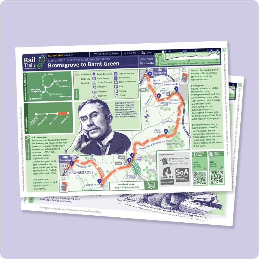

12.7 Km / 7.9 Miles | Moderate | > 3.5 hours
Route summary
A gentle climb north west in open country, following parts of the Monarch’s Way and Worcester and Birmingham Canal to Alvechurch, and finally to Barnt Green Station.
*** Please note
There is ongoing work on the canal currently which may lead to diversions.
Further details on the current situation may be found at The Canal Riverside Trust:
Towpath Closure – Shortwood Tunnel West Portal
Please check before starting your journey.
Interactive PDF Sheet Route 3
.GPX Route 3 file
Select your preferred line

The Cotswold & Malvern Line
The Cotswold and Malvern Line
The Cotswold and Malvern Line gives access to the famous Malvern Hills via Great Malvern and Malvern Link, the historic city of Worcester, and the picturesque market towns of Pershore and Evesham. NEW! Ledbury to Colwall walks.

The Wyre Valley Line
The Wyre Valley Line
The Wyre Valley Line runs through rolling countryside into the heart of Worcestershire connecting the villages of Hagley and Blakedown, Kidderminster, Hartlebury and the famous Droitwich Spa with the city of Worcester.

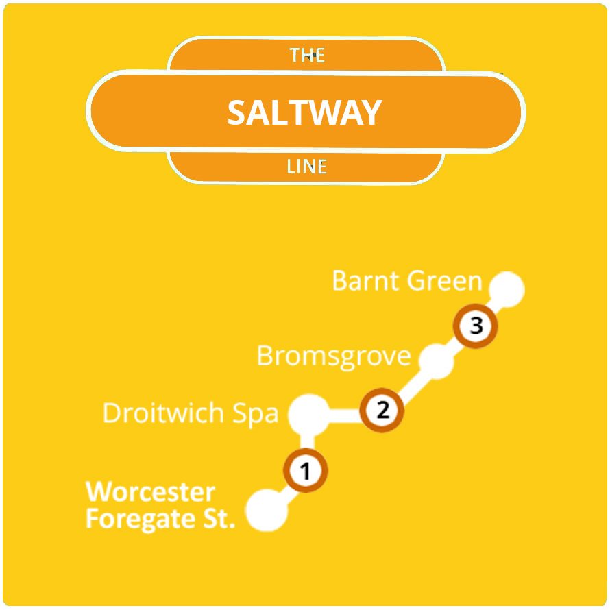
The Saltway Line
The Saltway Line
The Saltway Line connects Worcester with the historic town of Droitwich Spa, the market town of Bromsgrove and the charming village of Barnt Green offering access to the famous Lickey Hills.
The Arrow Valley Line
The Arrow Valley Line
The Arrow Valley Line provides access to the Lickey Hills at Barnt Green, canal walks at Alvechurch, and to the town of Redditch with it’s the needle manufacturing history.