Skip to content

Rail Trails | Worcestershire

Free station to station walking guides in Worcestershire
A project supported by
WCRP Logo

Welcome to the Rail Trails Project

Walkers on footpath
Malvern Train
Map sample
App on mobile
Rail Trails Overview

The Worcestershire Network

Worcestershire Rail Network Map

There are four rail lines running through Worcestershire providing easy and sustainable travel for locals and visitors alike.

They are:

  • The Cotswold and Malvern Line
  • The Wyre Valley Line
  • The Saltway Line
  • The Arrow Valley Line.

Worcestershire’s rich history and stunning countryside makes it a perfect destination for walkers wishing to explore the county, and Rail Trails is perfect for those wishing to arrive by train.

There are four rail lines running through Worcestershire providing easy and sustainable travel for locals and visitors alike.

They are the Cotswold & Malvern Line, the Wyre Valley Line, the Saltway line and the Arrow Valley line.

Worcestershire’s rich history and stunning countryside makes it a perfect destination for walkers wishing to explore the county, and Rail Trails is perfect for those wishing to arrive by train.

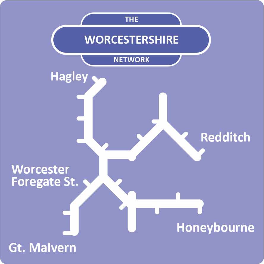
Select your preferred line

Great Malvern - Malvern Link - Foregate St - Shrub Hill - Parkway - Pershore - Evesham - Honeybourne

The Cotswold & Malvern Line

Great Malvern – Malvern Link – Foregate St – Shrub Hill – Parkway – Pershore – Evesham – Honeybourne
The Cotswold and Malvern Line

The Cotswold and Malvern Line gives access to the famous Malvern Hills via Great Malvern and Malvern Link, the historic city of Worcester, and the picturesque market towns of Pershore and Evesham.

Stourbridge - Hagley - Blakedown - Kidderminster - Hartlebury - Droitwich Spa - Foregate St

The Wyre Valley Line

Stourbridge – Hagley – Blakedown – Kidderminster – Hartlebury – Droitwich Spa – Foregate St
The Wyre Valley Line

The Wyre Valley Line runs through rolling countryside into the heart of Worcestershire connecting the villages of Hagley and Blakedown, Kidderminster, Hartlebury and the famous Droitwich Spa with the city of Worcester.

The Saltway Line

The Saltway Line connects Worcester with the historic town of Droitwich Spa, the market town of Bromsgrove and the charming village of Barnt Green offering access to the famous Lickey Hills.

The Arrow Valley Line

The Arrow Valley Line provides access to the Lickey Hills at Barnt Green, canal walks at Alvechurch, and to the town of Redditch with its needle manufacturing history.

Foregate Street to Droitwich Spa summary

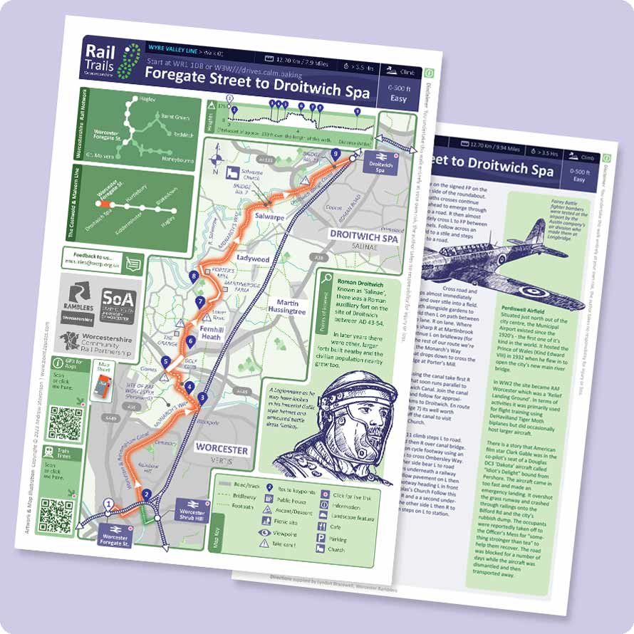
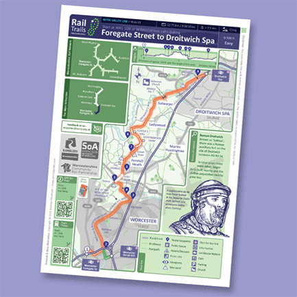
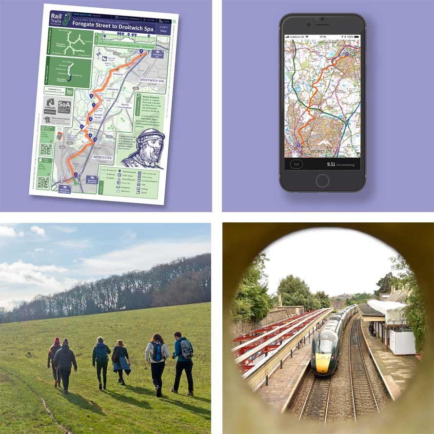
You can select a preferred line and then choose one of the Rail Trails that you can walk between stations. We’ve created 95 miles of entirely new walking routes running alongside the Worcestershire rail network. These have all been carefully digitally mapped with a set of bespoke newly-commissioned accompanying line illustrations per map sheet.

For that chosen walk, you can then download a PDF Route Guide, and also a GPX route file. Each PDF file is ‘interactive’ and you can click inside it to open links, when viewing on a device or phone.

Each sheet is A4 in size so it can easily print from a domestic A4 printer or they can be downloaded and viewed on a wifi or data-enabled device – phone or tablet. The downloadable linked .GPX file can be imported into your favourite walking app to be used as you wish too

Please note:
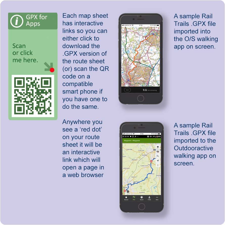
To use a GPX Route file, you will need an appropriate GPX viewer, which is a program or app installed on your device or phone. These can be found in the Android and iPhone App Stores.

There are many used by walkers and include, the OS Maps App, Komoot, OsmAnd for Open Street Maps, Garmin Connect, Strava, as well as free online GPX Viewers which can be found on the internet.

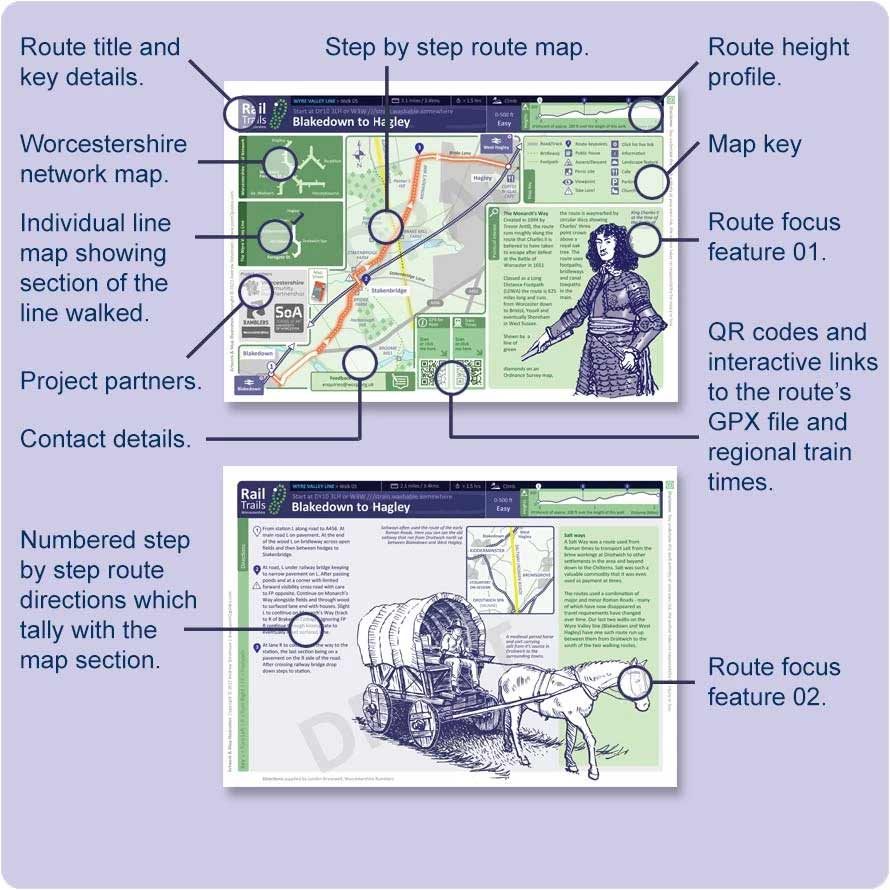
Choosing & using the map sheets

Map Features
  1. Choose your preferred line to walk
    Tip: browse our available lines above.
  2. Choose a preferred linear walk
    Tip: each line will have 3-5 linear routes.
  3. Download your preferred interactive .pdf
    Tip: you can view on your phone or print out.
  4. Click/scan QR codes to access the .GPX
    Tip: if you use walking apps (for example) O/S, Komoot or Outdooractive then you can add these files and use to navigate in this manner (see below for more).
  5. Consider buying the partner map(s)
    Tip: Each route sheet will show you the numbered O/S 1:25,000 scale map covering the individual route.

Interactive content
      Any red dots on these maps are ‘live’ links.

Using the .GPX files

GPX files overview
  1. Click or scan the .GPX link on your map
    Tip: this will have a ‘red dot’ to show it’s ‘live’.
  2. Download to your device or smartphone
    Tip: try to save in an obvious location.
  3. Open up your preferred walking app
    Tip: many of these are free to download too.
  4. Import your downloaded .GPX file
    Tip: every app is slightly different and will handle the downloaded .GPX in it’s own unique manner.
    Check the app’s details for GPX import and use.
  5. Use to navigate alongside a printed map
    Tip: Sometimes smartphones stop working. We strongly recommended that you take an OS Map and/or an A4 print out of the route sheets.
    The route sheets also help you double-check your route and cross refer.

Project team and partner organisations

William Whiting
WCRP Logo

William Whiting

Dedicated to the memory of William who helped set up the project for the Community Rail Partnership.

Fiona Saxon Partnership Officer
WCRP Logo

Fiona Saxon

Fiona is the Partnership Officer for Worcestershire Community Rail, and works with local communities and rail partners to enhance stations and promote active, sustainable travel.

Lyndon Bracewell
Worcestershire Ramblers logo

Lyndon Bracewell

Lyndon inspired the project and brings his wide experience in new walks creation as part of Worcestershire Ramblers to the project and route tests.

Andy Stevenson
School of Arts, University of Worcestershire logo

Andy Stevenson

Andy is the Senior Lecturer in Design at the University of Worcester.
He brings to the project his skills in information graphics and mapping.

Andy is currently also studying for a p/t PhD linked to the design and engagement with recreational walking route materials.

Rail Trails Footer